Search Icon

Explore Areas in Bangladesh

54 - 72 out of 302 areas
Kanaighat Property Guide
Rating icon
3.8

Kanaighat
, Sylhet

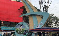
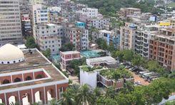
It has been said that there was a boatman named Kanai at the Surma River of Sylhet District. The area is named Kanaighat after him. However, there was no proof of the story, and there are many more tales behind it. Nevertheless, the Kanaighat area guide explores the landscape and beauty of this upazila, located in the northeast of Bangladesh.<br><br> Though the Kanaighat Upazila was established in 1983, it was a thana of Sylhet since 1880. Now, there are 1 pourashava, 9 unions, and 250 mouzas in the upazila. It has a land area of about 412.25 square kilometers and a population of 3,17,575 (2022 Census). The upazila is bounded by the Meghalaya State of India and Jaintapur Upazila in the north, Beanibazar, and Jakiganj Upazilas in the south, Assam State of India in the east, and Gowainghat, Jaintapur, and Sylhet Sadar upazilas in the west.<br><br> Being surrounded by several major upazilas and cities, Kanaighat offers broader transportation facilities across the country. Other than offering various communication routes inside the country, Kanaighat also offers transportation facilities beyond the border. However, the upazila roads and streets still suffer from the lack of proper development as there are more mud roads and many bus routes are not wide enough for better-traveling access. Several roads in the Upazila Sadar area are even damaged and have potholes.<br><br> Since the majority of the population in Kanaighat is Muslim, you will find several mosques in each village. There are more than 470 mosques all over the upazila, along with 30 temples and 2 churches. The upazila also has cultural organizations, political and sports clubs, religious services, community centers, banks, financial institutions, etc.<br><br> Among its over 150 educational institutions, the most notable ones are the Kanaighat Government High School, Kanaighat Government College, Kanaighat Women College, Durgapur High School And College, Jamea Islamia Yousufia Fazil Madrasa, Jhingabari Fazil (Degree) Madrasah, etc.<br><br> The most remarkable natural resource of Kanaighat is stone. The government earns a lot of revenue from Lovachora Stone Quarry in the upazila. Besides that, agriculture is the main economic source of the people in the upazila, which is about 48%. Other economic sources include non-agricultural labor, business, industries, jobs and services, remittance, etc.<br><br> 
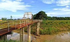
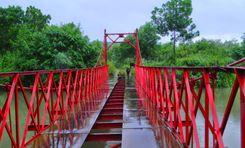
Kanaighat Upazila has many popular tourist spots. Among them, the Surma River, Andal Beel, Satbak Andu Lake, Lovachora Tea Estate and Park, East Barchatola Rubber Plantation, etc, are frequently visited by tourists.
View Insights
Kazitula Property Guide
Rating icon
3.8

Kazitula
, Sylhet

Kazitula has recently turned into one of the most sought-after locations in the Sylhet District. This suburban and residential cum commercial hub has been a home for thousands of people over the last few decades, and the population has been increasing day by day. Now, the Kazitula area guide shows that it is one of the most densely populated locations.<br><br> Kazitula's exact land area and population are unknown. It is located in the western part of Sylhet City and is part of Sylhet City Corporation’s ward no. 17. The Kazitula area is likely to be named after Kazi Jalal Uddin (R), as his shrine is one of the commonly known places of this locality. Kazitula is surrounded by areas like Kumarpara, Amborkhana, Shahi Eidgah, Lohapara, etc.<br><br> The area is filled with many tall buildings, most of which are residential apartments. However, you are also likely to locate some tin-shaded and semi-bricked households inside the localities and by the narrow streets. As a result, people who are looking for a residence in the area can easily find affordable options and suitable living spaces. There are also commercial buildings that offer affordable to high-priced spaces for establishing businesses. It shows that the Kazitula area offers a diverse living and social environment.<br><br> Other than housing and certain job areas, Kazitula also offers access to education. There are several schools, colleges, and madrasas inside and around the area. The reputed and well-known educational institutions in the area are the Kazi Jalal Uddin Girls' High School, Kazi Jalal Uddin Boys Government Primary School, and Madrasah Tahfizul Quran.<br><br> You can travel to Kazitula from Sylhet City by using the Ambarkhana or Chowhatta Point. Kazitula is located right across the Nayasarak and Ambarkhana Roads. Traveling to the area via buses, taxis, rickshaws, autos, and CNGs is convenient. The only problem is that the bus routes are not widely available via this road, and there are hardly any bus stops inside the area.<br><br> Jobs, businesses, and industries are the main economic sources in this area. Other than that, transport and services also contribute to Kazitula’s economy. So anyone staying in Kazitula or nearby localities can easily find safe and comfortable residential hotels. The Hotel Crystal Rose and London Inn are two such popular names.<br><br> The most notable landmark in Kazitula is the Kazi Dighi, which offers a view of a large and wide dighi at the center of the locality. There are also Kazi Jalal Uddin (R) Mazar Sharif, Kazitula Jame Mosque, Kazitula Uchasharak Jame Mosque, BTCL Guest House, BTV Station, etc.
View Insights
Kotwali Property Guide
Rating icon
3.8

Kotwali
, Chattogram

Right on the bank of Karnaphuli River, Kotwali thana rests with all its glory and reputation. This is one of the oldest and most prominent areas of Kotwali. Within a 6.25 sq./km area, this thana accommodates 43,000 households and many significant places of Chattogram. <br><br> Kotwali thana consists of 11 wards and 31 mohallas. This area is mostly known for residential purposes. You will notice both traditional architecture and modern-day establishments in some of the areas of Kotwali. <br><br> Beyond the residential use, Kotwali also carries significance in trade and commerce. As the area is situated at the shore of Karnaphuli River and neighbors Double Mooring and Khulshi thana, many port-based economies have flourished inside the Kotwali Thana. If you visit the coastal side, you will notice the boats and ships anchoring on the river. <br><br> Kotwali is a coveted area for many Chattogram residents. One prime reason is the establishment of some prominent and old schools. Government Muslim High School, Saint Placid's High School and Dr. Khastagir Government Girls' High School are some of the very best educational institutions in Kotwali. <br><br> Even though this area is quite densely populated, Kotwali is still a tourist hub. You can’t complete your Chattogram retreat without visiting the famous War Cemetry, hanging out in CRB chatter, or enjoying the sunset at Abhay Mitra Ghat. <br><br> Kotwali offers quite a bit of everything. Whether you are a house-seeker, business entrepreneur, student, or just a tourist, you will find all you need here. With the beautiful river, the age-old city of traditionality, and abundant opportunities in trade and commerce, Kotwali is indeed one-of-a-kind.
View Insights
Laksimipur Property Guide
Rating icon
3.8

Laksimipur
, Rajshahi

Laskimipur is an area of the Rajshahi megacity in Rajshahi District and Division. It is often confused with the Lakshmipur District of the Chattogram Division. That is why the Laksimipur area guide is here to help you.<br><br> The Laksimipur area falls under wards 6 and 7 of Rajshahi City Corporation and is part of the Rajpara thana of the district. Because the area is located near busy roads and highways, it is also one of the densely populated areas of the Rajshahi megacity.<br><br> Whether from the Court Station and Court Station Road or Ghora Chattor, Shaheb Bazar Road, or Medical Road, getting access to the Laksimipur area is very convenient. Since it is a local area, the most convenient means of transport are rickshaws, CNGs, cabs, bikes, etc. However, some routes connect to Laskimipur via bus as well.<br><br> A big part of the Laksimipur area goes by Court Station Road, while the other one goes through Greater Road and Medical Road. As the area has many medical centers, nursing homes, clinics, hospitals, Schools, and madrasas, it offers lots of living facilities.<br><br> In addition, the local roads are not very crowded, making Laksimipur ideal for settling in or renting commercial space. Moreover, the housing in the area is very affordable, and several new housing projects are currently under development to offer modern living facilities and access to many more amenities.<br><br> Some of the notable landmarks in Laksimipur are the Mintu Chattar or Laksimipur Mor, the Bangabandhu Mural in the Laksimipur Mor, Jhautola Mor, and Laksimipur Kacha Bazar. The area holds potential to be one of the prominent areas of the Rajshahi District.
View Insights
Madaripur Property Guide
Rating icon
3.8

Madaripur
, Dhaka

Madaripur may be overlooked like any other district of Bangladesh, but if you dig deep, you will realize It is an epitome of natural beauty, historical significance, and cultural affluence. In this Madaripur area guide, we will probe extensively the beauty and potential of Madaripur.<br><br> Madaripur is wrapped and webbed with numerous rivers. Padma, Arial Kha, Kumar, Krittinasha, Moynakata, and many more rivers have swathed the district from the beginning of time. Such affluence in nature has attracted many civilizations and people to settle here.<br><br> According to the latest update, Madaripur is surrounded by 1125 sq. km. of area and accommodates 12,93,027 people. The district has 5 sub-districts, 5 thanas, and 59 unions. According to the consensus, 9 rivers run from the Madaripur District.<br><br> The economy of Madaripur thrives on agriculture. The vast expanses of farmland produce a diverse range of crops such as rice, jute, wheat, and various fruits and vegetables. The fertile soil, coupled with the abundant water supply from the river, makes it an ideal location for agriculture, sustaining the livelihoods of the local population for generations.<br><br> Madaripur's rich historical landmarks include sites like the 19th-century Madaripur Court Building and the medieval Jor Bangla Temple, which illustrate the region's architectural and theological diversity. Madaripur is steaming with emblems of cultural significance. The vaunted date jaggery has spread its name and fame worldwide.<br><br> Despite its rural, agro-based surroundings, Madaripur has tremendous potential as a growth hub. Its strategic location along the river, natural resources, and lush terrain make it an appealing place for investment and growth.
View Insights
Mithapukur Property Guide
Rating icon
3.8

Mithapukur
, Rangpur

Mithapukur is a well-known upazila located in the Rangpur district of Bangladesh that cherishes the heritage of Rangpur. This Mithapukur is the holder of the history and culture of Bangladesh. Mithapukur is located in the southern part of Rangpur district. It has Rangpur Sadar to the north, Pirganj to the south, Badarganj and Phulbari to the west and Pirgacha and Sundarganj to the east. Mithapukur is the largest upazila of Rangpur both in terms of area and population. Its total area is 515.62 km and its population is about 508,133 people. Yamuneshwari, Akhira and other rivers flow through Mithapukur which adds to its natural beauty. Mithapukur became a Thana in 1885 and upazila in 1893. This upazila is located about 20 km south of Rangpur city.<br><br> The economy of Mithapukur is mainly based on agriculture, agriculture is the main source of livelihood for most of the residents here. The fertile land here supports the production of paddy, jute, wheat, sugarcane and various vegetables. Haribhanga mango also originates from this region. Besides agriculture, small scale businesses contribute to the local economy. Mithapukur also has a rich historical background. It was established during the Mughal period. There are several historical places of that period and they are of great importance. There are several historical mosques, temples and old buildings that reflect the architectural style of the Mughal and British periods. A unique sign of natural beauty is the combination of green fields, rivers and ponds in this place.<br><br> Mithapukur has several educational institutions including primary and secondary schools, colleges and madrasas. Which is improving the education here while for higher education there is Begum Rokeya University which is well connected with Mithapukur by road. Medical services like education are also quite satisfactory. Medical services are provided here by upazila hospitals and government and private institutions.<br><br> Mithapukur is well connected by road with Rangpur city and other nearby areas. Public transport like buses and rickshaws are commonly used for local travel. The upazila is also accessible through major highways connecting Rangpur and other major cities of Bangladesh.<br><br> Mithapukur's cultural life is vibrant, with traditional music, routines and festivals an integral part of the community. Religious festivals like Eid, Durga Puja, Pahela Baishakh are celebrated with enthusiasm. Which reflects the tradition of Rangpur along with the growth of only Mitha Pond tradition.<br><br> Mithapukur upazila of Rangpur has deep historical roots and beautiful scenery. Such a calm and soothing environment to live in is truly unmatched. As one explores Mithapukur's serene beauty and historical monuments, it becomes clear that this upazila is not just a place on the map but a vibrant community that embodies the essence of Bangladeshi life. The warmth of Mithapukur people, the charm of this rural area and the Rangpur region is a gem. It is a place where history and nature create a truly memorable experience.
View Insights
Mohakhali Property Guide
Rating icon
3.8

Mohakhali
, Dhaka

Mohakhali is one of the most important commercial, residential, and connectivity areas of Dhaka, the capital of Bangladesh. The area has various government and private offices, business establishments, and residential complexes. It is mainly known for communication links and transportation. One of Dhaka's major bus stands, highways, and elevated expressways are located here. Due to this good connectivity of the communication system, one can travel from here to any part of the city, even to all the cities of the country.<br><br> Several government departments, corporate offices, banks, and educational institutions, including BTRC, BRTA, Chest Hospital, BRAC Centre, ICDDR, etc. make this area a busy commercial hub. There are also planned residential buildings, DOHS, and small to medium housing complexes. The area is widely recognized as an affluent residential area for its advanced educational institutions, good connectivity, and healthcare facilities.<br><br> Elevated expressways, modern infrastructure projects, commercial complexes, and planned residential buildings have been constructed in the area in the last few years. Several other development projects are underway. Bus terminals, hospitals, business establishments, restaurants, community centers, shopping malls, etc. make this area one of the busiest towns in Dhaka. Parks, lakes, and sports fields have been created here for the residents' entertainment even in such a dense settlement. DOHS Park and the picturesque surroundings of Hatirjheel will enchant you.<br><br> The Mohakhali area is neither serene nor quiet, it is crowded and bustling. The DOHS area of Mohakhali is one of the most affluent residential areas in the country. Advanced medical services are available at low cost in most of the medical institutions here, due to which people from different parts of the country come to Mohakhali for advanced treatment. With healthcare facilities, distinguished educational institutions, delicious restaurants, and shopping centers, the region has all the facilities to meet its residents' needs.<br><br> There are many residential buildings and apartments in this area due to its economic importance, including educational institutions, hospitals, public and private offices, and banks. Many startup businesses and IT companies have developed here. Also, the importance of this area is immense from an administrative and socio-economic point of view.
View Insights
Nawabganj Property Guide
Rating icon
3.8

Nawabganj
, Dhaka

Nawabganj is an Upazilla of Dhaka, set at the shore of Ichamoti River. Settled at the 35-kilometer southwest of Dhaka city, Nawabganj is a confluence of history and development. Due to the demographic location of the area, it is one of the influential parts of Dhaka for trade and commerce. Nawabganj is not a city of recent times. The name itself implies its rich history and its connection with the Nawabs of the Nawabi Period. The upazila is surrounded by three rivers. These are Ichamoti, Kaliganga, and Padma river. This unique feature makes it an economically viable junction for exchanging goods. The Nawabganj Upazila is a merge of 14 union parishads. The recent consensus reveals that the area has 70,757 households and 318,811 people. As the area's strategic location is quite predominant, its political influence is something you can’t ignore. You will notice the influence of politics in commerce and day-to-day lives there. The area became a hot topic of discussion when the day-trip culture suddenly became popular. To spend a day away from the hustling and bustling of Dhaka city, Dhaka-dwellers started to seek destinations adjacent to Dhaka where they could make a day out of it. The natural demeanor and historical significance made Mawabganj a tourist attraction. Friends and families are now rushing to Nawabganj whenever they get a chance to connect with nature, breathe fresh oxygen, and enjoy the serenity of the Ichamoti rivers. Such a boost in tourism is uplifting trade and commerce and invigorating the fate of the economy of the Nawabganj Upazila.
View Insights
Paikgachha Property Guide
Rating icon
3.8

Paikgachha
, Khulna

If you travel from the Khulna Sadar area via bus, you can go directly to Paikgacha Zero Point. But during the journey, you can stop in a few other areas, such as Chuknagar, Atharomile, Kapilmuni, Tala, etc. You have guessed right! Today, we will share the Paikgacha area guide and everything you need to know about the Upazila and its various localities.<br><br> The Paikgacha Upazila is located in the southern areas of Khulna District, near the Sundarban Mangrove forest. It is about 65 kilometers away from the Khulna Sadar and has a land area of 383.27 square kilometers. The population of Paikgacha upazila is nearly 2.50 lakh.<br><br> Paikgacha is also regarded as the White Gold of Bangladesh because it is renowned for shrimp farming. Bangladesh Fisheries Research Institute (BFRI) Brackish Water Center and various shrimp farms are located in this upazila. The shrimp price in the area is lower than in other areas. The economy of the people in the area also relies on agriculture, dairy, and poultry.<br><br> It has many ancient and historical landmarks. Some of the popular and notable places are Paikgacha Zero Point, Sir P.C. Roy House, Bakabazar Jomidar Bari, Saral Kha Dighi, Sree Sree Ramakrishna Sevashram, Pir Jafar Aulia Shrine, etc.<br><br> Other than these, the Paikgacha Fantasy Park and Garden is another attraction for locals and tourists. The Kopotakkho River also flows through the upazila. However, Paikgacha upazila still requires some additional sources of amenities, such as shopping centers, service centers, restaurants, and more.<br><br> Paikgacha upazila is always bustling with life. The bazaar and market areas keep people engaged with daily businesses throughout the day. It also has many educational institutions, mostly primary schools. It also has many religious institutions, such as mosques, temples, churches, etc. There are several financial institutions and offices in Paikgacha as well.
View Insights
Patenga Property Guide
Rating icon
3.8

Patenga
, Chattogram

Patenga is a stunning coastal area under the Chattogram City Corporation. It’s just 14 Km south of Chattogram. Patenga is famous for its ideal location in the Bay of Bengal. It has a unique mix of natural beauty and well-facilitated accommodation. This is why every year many people visit this place and enjoy the lively rhythms of nature.<br><br> The main attraction of this area is the smooth communication from the peaceful beaches. This area has a lot of different places to live, so it can suit people who want the peace and quiet of living by the sea or who want to be close to the benefits of city life. Also, this is an area that offers a variety of food-tasting opportunities, from delicious fish to food from around the world. You can also easily get to places to shop for everything from traditional crafts to modern stores.<br><br> Patenga has big and well-managed roads and the place is very close to major transportation routes, Which is a great plus point for visitors.<br><br> Patenga is not just about the lovely sites and views, it also has many schools and hospitals nearby, making sure that residents can get the services they need. Some cities may have more residential facilities than this one, but the beach is a great place to play in nature and get away from the busy city life, which adds to the area's charm.<br><br> As the only beachfront community in a big city, Patenga offers a lifestyle choice that can't be found anywhere else in Chattogram. It combines the best of coastal beauty with city conveniences, making it a great place for both relaxing and living a busy city life.
View Insights
Pirojpur Property Guide
Rating icon
3.8

Pirojpur
, Barishal Division

Located in the southwestern part of Bangladesh, Pirojpur District is part of the Barishal Division, known for its scenic rivers and lush green landscapes. Covering an area of about 1,277.80 square kilometers, Pirojpur has a population of approximately 1.2 million people. This Pirojpur area guide provides an overview of what makes the district a charming and vibrant place to live.<br><br> The district is bounded by Gopalganj and Barishal in the north, Barguna in the south, Barguna and Jhalokathi in the east, and Bagerhat and Sundarban to the west. It is said that Subedar Shah Suja’s 2nd son, Feroz Shah, died in this area, which got it the name Ferozpur. However, with time, the pronunciation changed to Pirojpur.<br><br> The district's land varies between town and countryside, with the urban parts like Pirojpur Sadar offering better housing facilities. In contrast, most of the rural parts consist of traditional houses, often made of tin, bamboo, or mud, surrounded by agricultural land and water bodies.<br><br> The town areas are more developed, providing easy access to markets, schools, and healthcare, while rural areas enjoy a quieter lifestyle close to nature but may lack some modern amenities. However, the district is well connected by road and waterways, with frequent bus services linking it to nearby districts and major cities.<br><br> The economy of Pirojpur is predominantly based on agriculture, with rice, guava, and betel leaves and nuts, coconut, etc., playing significant roles. Education is supported by several schools, colleges, madrasas, etc.<br><br> Healthcare facilities include government hospitals and private clinics, but many residents travel to larger cities for specialized treatments. Pirojpur also has numerous religious institutions, including mosques, temples, and churches, reflecting the district's cultural diversity and religious harmony.<br><br> The district's natural beauty is one of its defining features, with rivers like the Baleshwar and Kocha providing stunning landscapes. The district is also dotted with green paddy fields, dense forests, and a variety of wildlife, offering a serene environment for residents and visitors alike.
View Insights
Rajbari Property Guide
Rating icon
3.8

Rajbari
, Dhaka

Curled up at the bank of the Padma River, Rajbari District stands with a rich tapestry of culture that is entwined with the history of Bengal. Not only Padma River, if you visit Rajbari, you will be welcomed by Hori, Gorai, and Chandona Rivers as well. Located at a distance of 150 Kilometers from Dhaka, Rajbari has been attracting tourists and would-be-residents, making it essential to check out the Rajbari area guide.<br><br> Rajbari is a part of the Dhaka division and was declared a district in 1984. However, its existence predates the emergence of Bangladesh. It was established in the 18th century and named after King Surja Kumar, Jaminder of the Lakkhikol estate.<br><br> Modern Rajbari is comprised of five sub-districts, three Pourashava, and 42 unions. The district surrounds an area of approximately 1,118.8 sq. km and currently nurtures around 1,049,778 people.<br><br> The economy of Rajbari rests primarily on agriculture. Due to its fertile alluvial lands, rice farming has always brought profit and interest. Fishing is also a big part of its economy. Moreover, Rajbari has outshone other districts in jute production. Sugar, onion, garlic, and other root vegetables are also abundant here.<br><br> After the inauguration of Padma Bridge, the intercommunication system in Rajbari has shifted its dynamics. The distance duration has been depleted and curtained in short. The bridge connected the city with Dhaka and the northern part of Bangladesh. This connection has elevated the trade and commerce in the area.<br><br> As the distance grew smaller, Rajbari became a spot for recreation and day-long for the people of Dhaka. As the district is replete with historical and cultural landmarks, many local and foreign tourists choose Rajbari as their part of exploring beautiful Bangladesh. Moreover, the trade and business prospects attract more people as residents of Rajbari.
View Insights
Saidpur Property Guide
Rating icon
3.8

Saidpur
, Rangpur

Of all the places you could check out in the Nilphamari District, the Saidpur area guide is one of the most sought-after ones. Why? Because it is one of the developing lands with good prospects for the future. Saidpur is an upazila of Nilphamari District and an administrative area of the Rangpur Division. Not only is it a beautiful location, but it is also rich in history and landmarks.<br><br> Saidpur was a bazaar or market area of Rangpur District’s Daroani thana before 1870. However, it was turned into a Sadar thana area under the Nilphamari District, active from 1870 to 1915. Then, in 1915, Saidpur became a separate thana area. Later, in 1982, Saidpur became an established upazila or sub-district under the Nilphamari District.<br><br> The upazila's land area is now 121.68 square kilometers, and its population is 3,12,988 (2022 Census). It is bounded by Kishoreganj Upazila and Nilphamari Sadar in the north, Pirbatipur and Badarganj Upazilas in the south, Taraganj Upazila in the east, and the Khansama and Chirirbandar Upazilas in the west. The known river bodies in the area are the Chikali and Kharkharia Rivers.<br><br> Though the rural people of Saidpur rely on agriculture as their economical source, most people in the town area are related to jobs, businesses, various industries, and crafts. Other than paddy, potato, wheat, and various vegetables are also commonly harvested in Saidpur.<br><br> With the developed roads, bypasses, and highways, communication is excellent in Saidpur, making transport easier for other parts of the district and country. However, there are still many underdeveloped and undeveloped roads that often impact communication. The upazila has two railway stations and an airport nearby.<br><br> Because of the airport area, the land price around the location has suddenly increased. However, you can still find affordable land and property options in Saidpur. It also offers facilities like education, training, healthcare, finance, and more. It also has notable religious institutions, like mosques, temples, and churches. The Chini Masjid in Saidpur is one of the famous landmarks in the upazila.<br><br> There are also Murtuza Institute, Lokkhonpur Jomidarbari, Saidpur Theme Park, etc. The upazila has a cantonment area. Some of the notable educational institutions in Saidpur are Noyatola Government Primary School, Saidpur Muslim High School, Saidpur Women's College, Saidpur Technical School & College, Saidpur Cantonment Public School & College, Bangladesh Army University of Science and Technology, etc.
View Insights
Sandwip Property Guide
Rating icon
3.8

Sandwip
, Chattogram

Once known as a land of business and trade, the Sandwip upazila or Sandwip Island of Chattogram District used to have a vast land area of 630 square miles. However, the upazila lost its land over time due to various natural disasters. Now, it only has a land area of about 80 square miles, which is 25 miles in length and 3-9 miles in width. The population of Sandwip is around 3,27,533 (2022 Census).<br><br> According to the old Sandwip area guide and history written by the Europeans, the island is over 3 to 4 thousand years old. It was known for producing salt and manufacturing ships and garments. There are also many debates and theories on how the island was named. Some people say that there were no men on the island when Baro Auliya discovered it. They named it Shunno (Zero) Dip (Island), which later turned into Sandwip. Others say that Europeans named it Sand-Heap as the land was filled with sand and was later called Sandwip.<br><br> However the name came, Sandwip remains one of the most beautiful landscapes of Bangladesh, surrounded by the Bay of Bengal, Chattogram, Companiganj of Noakhali, Hatiya Island, Bamoni, and Meghna Rivers. While it is still one of the prosperous land areas, the lack of proper transportation facilities has made the island remote and less accessible. The only means of travel to the Sandwip Upazila is the ferry terminal from Kumira Ghat of Sitakund. There are no buses or bus routes inside the Island either.<br><br> Sandwip was formed by silt deposits from the Meghna River’s estuary, which is highly fertile and suitable for agriculture. Along with rice, jute, potato, betel nuts, sugarcane, radish, mango, and jackfruits, many other crops and fruits are grown in the land of Sanwip Upazila.<br><br> Even though it is a remote Island, the seaside and natural beauty of Sandwip attract many national and international tourists every year. Some of its popular and well-known locations are Sandwip Sea Beach, Travelly Eco Village, the Sandwip Channel, and the Bay of Bengal.<br><br> The area is prone to natural disasters, which is why it has several cyclone shelters to ensure people’s safety. However, one of the upcoming projects in Sandwip includes the construction of a jetty, which will make communication with the mainland more accessible and ensure better safety in the future.
View Insights
IconMap

Featured Projects

View All

Property Price Trends in Bangladesh for

Buy
Rent
Bedrooms:
Average Price (Last 12 months)
BDT 6,428.06 per sqft
Past 12 months' growth
11.11%
Positive Trend
Past 3 months' growth
13.4%
Positive Trend
Icon
Price information is based on historical data from ads posted on Bikroy and may not reflect the full market dynamics.
hero

Sell or Rent Fast on Bikroy: Post Your Property in 2 Mins!